(This blog post I wrote for the Central Eurasian Studies Society in July 2015 has now become an excellent lesson in the ephemeral nature of the Internet. When I wrote it almost ten years ago it was to celebrate the availabilty of a set of maps, digitized and available from a University in Sweden… and now all of these links are dead, the maps maybe? still available.
The maps brought to Europe from Central Asia by Johan Gustaf Renat (1682-1744) in the early eighteenth century are little known outside a small circle of specialists.
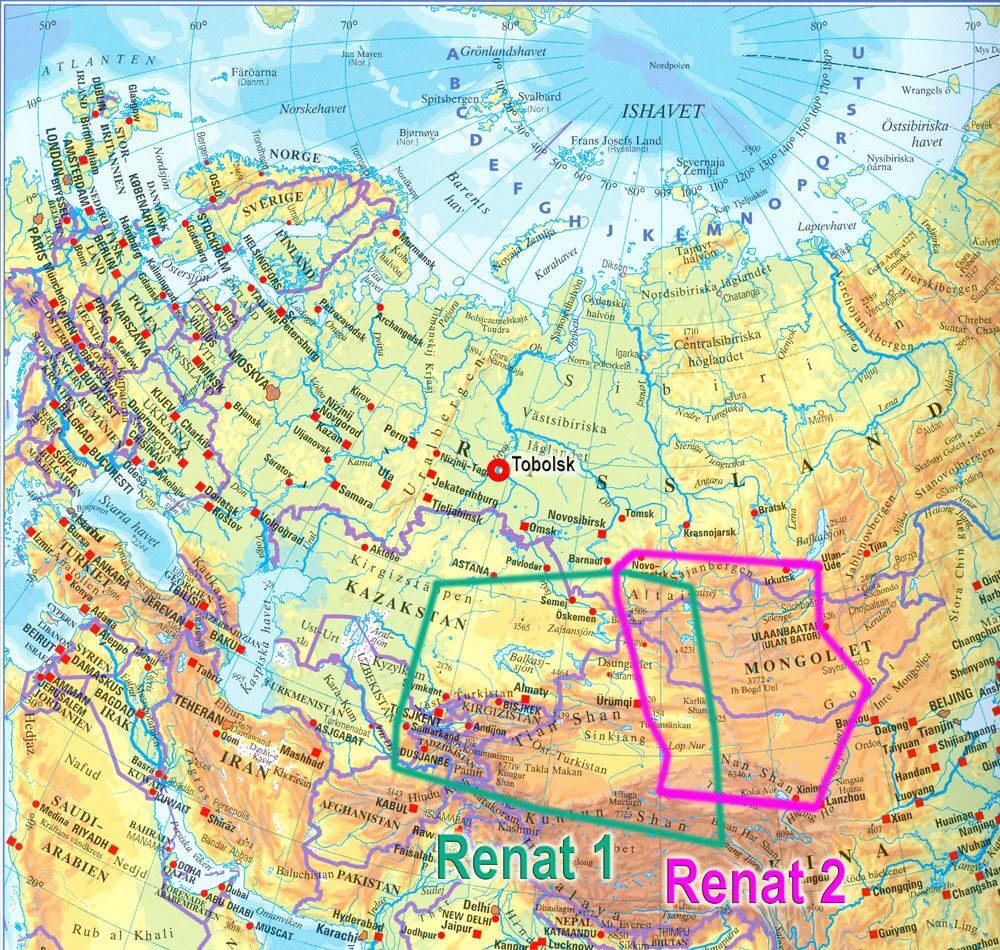
The two maps, together with sketches, copies, and translations provided by Renat and others are now available to the English-speaking public, following several centuries of being nigh unreachable. Housed in the library of the University of Uppsala since June of 2010, thanks to the efforts of Professor Emeritus Staffan Rosén, the maps have been digitized in very-high resolution and researchers around the world can zoom in as far as they would like when parsing the Oirat script. The maps include over seven hundred place names, a useful source for comparing the Oirat “clear script” with its parent Mongolian script and other neighboring writing systems.

This next section assumes a linked image that no longer exists.
For example, let us examine a small snipping of a map detail from the website, with a South-Up orientation. Both the original Oirat script and the Indexing of place names in Latin script are visible: № 24 – Tashkent, № 25 – Sayram, № 26 – Syr Darya, № 27- Yasi [Turkestan], № 30 – Arys River. The two parallel lines crossing from top center to lower right represent the Syr Darya, with tributaries flowing into the river. The curved lines along the bottom and left-hand margins represent the mountains, both the western Tien Shan east of Tashkent and the Karatau mountains north of Yasi. What I find interesting about this map is that mountains are not drawn as curved or pointed lines, but by lines which seem to represent a constant elevation threshold. In other words, inside the curved borders of a mountain shape, the land rises above some set limit, for example approximately 1500 meters above sea level.
Renat’s maps have received some attention since their rediscovery in Uppsala in the late nineteenth century, mostly in Russian- and English-language studies of Central Asia. The most famous, perhaps, was the long treatment in John Baddeley’s 1919 colossal Russia, Mongolia, China, a two-volume analysis of maps and travel accounts which included valuable reproductions and overlays comparing maps with each other and with up-to-date 1919 maps. Göran Bäärnhielm of the Royal Library in Stockholm has synthesized most of the scholarship, briefly and in English, on his personal website (in English with clickable map scans) Bäärnhielm had offered one of the presentations when the Renat maps were moved to their current home in the Uppsala University Library back in 2010.
For readers of the CESS Blog who, like me, are sadly illiterate in Swedish, the road to the maps’ online home is thankfully simple. First, navigate to the Image Search (Bildsök) page of institution’s website in Swedish. Here you may type any keyword, but in this case simply using Renat’s name may be simplest. So, type “Renat” in the search box and click the Search (Sök) button. This should bring up a page of results like the example image posted here, listing the original maps (Renat 1/A and 2/B), the various copies, and a few accompanying manuscripts (e.g. Renat’s key to his № labels).
These maps are particularly useful in helping to illustrate the geographic and political landscape, as Renat’s copies included both commentary, ethnonyms, and approximate boundaries of the neighboring peoples in the region. There is much in this treasure trove that may interest the historian of “early modern” Central Asia; for example, the high degree of cartographic accuracy when compared with contemporary and even early nineteenth century European maps of the region allows one to wade into the debate of whether these maps represent an indigenous map tradition or an off-shoot of a Chinese cartographic school.
In another example, one could productively compare Russian and Jungar mineral ambitions for the region in Renat’s maps, particularly with regard to Renat’s focus on placing rumored locations of gold mines. While Peter I sent two failed expeditions to the region in the early 1700s, historians do not typically view the invasions into Western Turkestan during the reigns of Galdan Boshugtu Khan (1644-1697, r. 1670-1694/97) and Tsewang Rabtan (1643–1727, r. 1694-1727) in a similar light. But from whom did Renat learn of goldmines in Tashkent if not from his Jungar captor, and the purported author of the maps, Tsewang Rabdan?