I wrote this blog post for the Central Eurasian Studies Society in 2015 and with the passing of their blog, this post has no home. With the ephemeral nature of the Internet, aren’t I just delaying the inevitable?
Can the subaltern draw a map? This post attempts no answer to the question, but rather illustrates how a non-European habitat’s invisibility in modern “scientific” geography might raise the question of national or other biases in cartography.
Perhaps it goes without saying that Middle, or Central, Asia is not a region of many different ecological zones. It is vast, but not varied. Deserts, mountains, oases, rivers. The other areas can be waved into (or out of) view as man-made, built up through herculean effort with countless spades of dirt lifted from countless irrigation canals, ditches, and reservoirs. The Russian Conquest and later collectivization heralded an increase in labor rather than a true alteration of the land-economy: more and larger canals, ditches, and reservoirs.
There is one habitat that was once widespread throughout the region, stretching from Eastern Turkey through the river lowlands north of the Caspian to the Aral plains and reaching past the Ili River and other basins in the Seven Rivers region of southeastern Kazakhstan as far as the rivers of the Gobi and even to the Tarim Basin, where one may visit the Huyanglin Nature Reserve, established in 1983.
This ecological zone is called tugai. It is an important habitat for various species across Eurasia and would likely remind most CESS blog readers of a sandy jungle–short trees and thick undergrowth giving way to impenetrable reed-beds along shifting streams and bogs. Apart from a wealth of birdlife and smaller creatures, the tugai before the previous century supported a variety of wildlife, including large mammals like deer (Cervus elaphus bactrianus) and the Caspian, or Turan, tiger (Panthera tigris virgate) – all within the larger ecosystem of the desert-steppe. The prairie-dwelling saiga antelope (Saiga tatarica) and the ever-present wolf (Canis lupus campestris) depended on the river- and artesian-water of the tugai. Not only the saiga and the wolf, but also the steppe-dwelling peoples were continuously drawn to Tugai. The steppe provided little useful timber, but the Tugai offered the lithe branches of willow and poplar trees useful in the construction of their bows, arrows, and felt-covered homes.
But where was the Tugai, exactly? This is not something one can point to on a map, barring in the narrow case of the aforementioned nature preserve in China. Consider this excerpt from an 1850 revision of an 1843 map — “Iran und Turan.”1
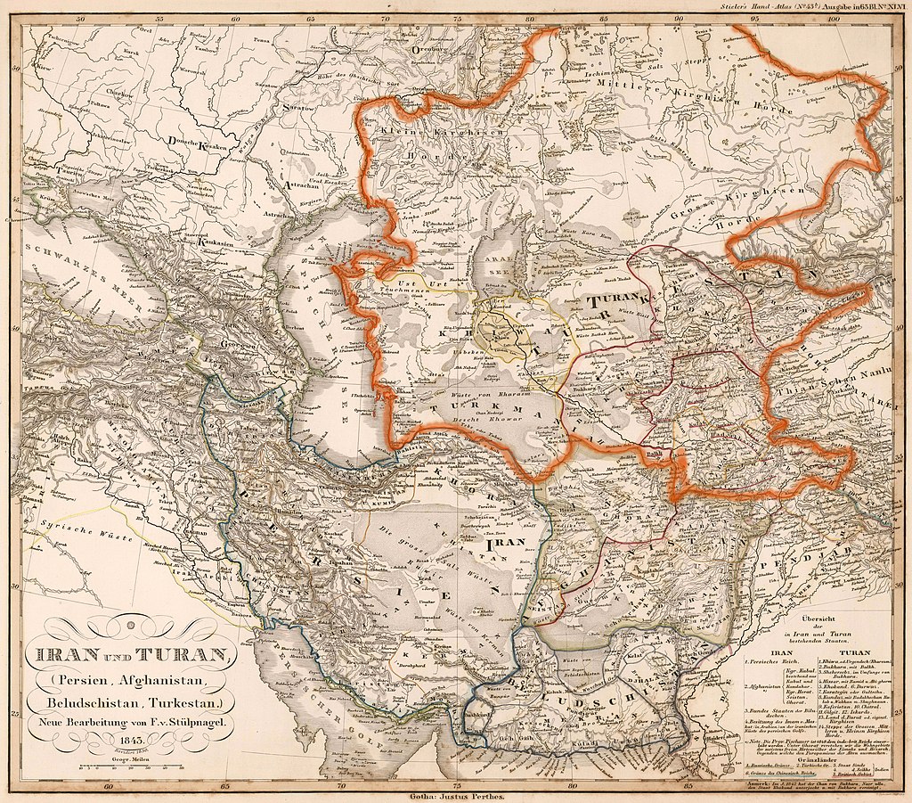
The map is beautifully drawn, with colored borders showing both sovereign territory and “areas of control.” In the case of Khiwa (Khiva), the immediate environs are shaded yellow, with a neighboring area surrounded by a dotted-yellow-line border, illustrating the broader domains of the Khanate of Khiva.
The map uses several commonplace cartographic conventions. The geographer drew masses of closely clustered dots to show deserts, millipede-esque lines for mountain ranges, stacks of parallel lines for massifs and hills, and black lines of varying thickness to show navigable and shallow rivers. The map includes vast blank areas, particularly in Iran and the vast steppelands from Kiev and Poltava in the West to the See Tenghiz/Bakaschnoor (Lake Balkhash) in the East. Occasionally wetlands are indicated, if large enough; such is the case for the swamps along the shores of the Caspian near Astrakhan and east of the Ural River north of Gurjew (Atyrau). Nowhere on the map, however, would one find the tugai.
The tugai was invisible, despite the fact that it remained, at the time of the map’s creation, an unbroken line of habitats. It supported tiger populations—which is to say it supported large deer populations—throughout the extent of this map, with especially dense clusters along stretches of the Caspian coast, the shores of the Aral Sea, and the river-lands of the Amu Darya.
Let us consider a more detailed map, from later in the nineteenth century. This excerpt from an 1872 atlas sends some mixed messages.

This portion of the map focuses on the southern shores of the Aral Sea and the Amu Darya delta. Following nearly the same conventions seen in the previous map, the cartographer shows hills, cliffs, rivers, and swamp-lands throughout the historic range of the tugai. Perhaps the exotic nature of the tugai prevented foreign observers from adequately explaining what they had observed, which in turn prevented the cartographers from expanding their own graphical vocabulary to include this distinct landform.
This continues more or less to the present – compare with this excerpt from a mid-20th-century map of the region, and attached legend.3 In the modern landscape, still before the desiccation of the Aral Sea, the coastal and river tugai are represented by a confusing collection of map symbols, representing marsh, sand, and salt marsh almost simultaneously.
Adding another ecological symbol to map an area so far from the centers of power may have seemed unnecessary, then and now. The few visitors to the area in the nineteenth century generally saw the tugai only from a distance, i.e., from the decks of river-going ships or from the backs of horses or camels. Has so much changed? At least in the “bad old days,” the luckiest of the exploring officers engaged in the most dangerous of sporting outings – the tiger hunt.
The Caspian tiger is extinct today.4 The Soviet Union made a minimal effort to preserve a small portion of habitat in arguably its least developed republic, opening the first Central Asian zapovednik (nature preserve) in the Tajik SSR in 1938, following a tiger attack. The last traces of the tiger population in Tajikistan appeared already in 1958, and the last wild Caspian tiger seen anywhere was shot in Turkey in 1970. Following preliminary studies, however, an international team of scientists is recommending re-populating the Tugai of Central Asia with Siberian (Amur) tigers.
A century ago, the desert [that is now around the Aral Sea] was known as the Reed Kingdom – a marshy delta area where the Amu Darya widened as it approached the Aral Sea. Bird life and wild boars abounded, and there were enough Aral Sea tigers that, according to Russian records, between 1886 and 1891 about 200 people were eaten by them.
Aral Sea: an environmental disaster to rival Chernobyl
https://geographical.co.uk/science-environment/aral-sea-an-environmental-disaster-to-rival-chernobyl
The feasibility study produced an astonishing map, showing the historical range of the tiger, and some of its tugai habitat.5 Moreover, the Amu Darya delta south of the vanished Aral Sea retains enough tugai to possibly support a new tiger population… but the suggested acreage had already been leased to the government of China for oil and gas exploration.
The study concluded by suggesting that the Seven Rivers region of Kazakhstan provides a better economic and political climate for the reintroduction of tigers, an area which also has had unconfirmed sightings of the supposedly extinct Caspian tiger.
In closing, this post may seem to offer fodder to those fighting in the trenches of modernism, Orientalism, and cultural studies. I would only add a few words of caution. This critique of “silenced” subaltern cartographers is itself suspect, in my opinion. What is the aim of this writing if not for the advancement of science? Will an addition of a new graphical convention to cartography make any meaningful change in the understanding of east by west, or vice versa? The mapping of tugai is important and useful, but perhaps the study of the slow realization by post-Soviet scientists in recent decades of its very existence is even more useful.
1 Available online from http://vambery.mtak.hu/en/03.htm The website honors the famous Hungarian traveler and Anglophile Ármin Vámbery (1832-1913) and was put together in recognition of the 100th anniversary of his death. It includes a wealth of valuable archival material, including pictures, maps, and manuscripts.
3 1959 Composite map of Siberian USSR, David Rumsey Map Collection
4 Cheryl Lyn Dybas. “The Once and Future Tiger: Central Asia’s “extinct” Caspian tiger and Russia’s Amur (Siberian) tiger have a past—and perhaps a future—in common.” BioScience 60, no. 11 (2010): 872-877.
5 http://www.wwf.ru/resources/publ/book/eng/460 Pre-feasibility Study on the Possible Restoration of the Caspian Tiger in the Amu Darya Delta. Hartmut Jungius, Yuri Chikin, Oleg Tsaruk, Olga Pereladova. 2009.